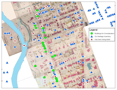
I recently received an introduction to GIS from Don Lafreniere, a graduate student in the Geography Department of UWO. Don showed some of my fellow students and me the things they were doing with GIS as historical geographers, much of which related directly to public history. For example, my classmates and I are currently researching homes in London neighbourhood to determine whether they qualify as historic resources. One criteria of significance in Ontario is contextual value, where the property is important in defining, maintaining or supporting the character of an area, or is physically, functionally, visually, or historically linked to its surroundings. (Designating Heritage Properties, Ontario Heritage Toolkit). We asked Don to create a map including all of our buildings, all the buildings in the area that are already designated, and all the buildings in the area that were included on the most recent heritage inventory (meaning they have been identified as significant but not yet designated). The resulting map took him only a few minutes to make, but should prove very useful when we argue for the contextual worth of our buildings to the local heritage review board.
GIS is certainly not new technology to heritage planners, but volunteer heritage boards have likely not had as much experience with the possibilities presented by GIS. Having someone at the meetings manipulating maps in real-time would make their decisions of what to designate, particularly when it comes to heritage areas, much easier. Saving the sequence of maps they created and viewed would also help them explain their reasoning latter, and would help establish more concrete precedents for them to look back on in the future.
One project the UWO geographers are working on is using GIS to map historic photographs, which would be an amazing resource for archives and those researching in them. The basic idea is to scan historic photos, tag them using Picasa(free software from Google) and then plot them with GIS so they will appear as points on a map. This project employs two of the most commonly used archival resources, maps and photos, and will help archives make these materials more accessible both physically and intellectually.
Because many of the users of an online geographically referenced historic photo collection would be non-academic, it is worth discussing how we can get the public to engage in the project. One way in which this could be done is through folksonomies (see The Hive Mind: Folksonomies and User-Based Tagging). Many archival collections have hundreds of thousands, if not millions of photographs, and the volume is far too large for archives, which struggle for funding as it is, to do it themselves. Having denizens of the internet tag the photos with geographic locators and keywords is a reasonable solution. One of the major criticisms of such an approach is that there is no unified language used in the description. For this reason, I would advocate creating an extensive list of keywords from which the user would have to choose, based on a codified list of terminology commonly accepted by archives, such as the UNESCO Thesaurus. An “other” category could exist which would allow the user to create their own tag, but it could not be the only identifier used. The “other” field would allow users to create their own meaning out of photos while giving project administrators an idea as to any popular tags they may have missed. Controlling the tags would also eliminate spelling errors, and allow for both keyword searches and Faceted Navigation.
Unfortunately, GIS is proprietary software and is currently too expensive for many non-profit institutions. However, the potential is there for an extremely useful, interactive tool that would help promote and engage the public with their past.

Tim,
ReplyDeleteReally interesting post. Thanks!
Sandra
(Wish I hadn't had class and could have come to this)
Tim, there are some open source geospatial options. See the OSGeo projects, including GRASS at http://www.osgeo.org
ReplyDelete