Recently my fellow students and I have been discussing data mining and its implications to public historians. One of the articles we discussed was Dan Cohen's blog post What Americans Did on September 11, which in essence is an explanation of how he created a simple map using Google Earth to represent regions of the US, and whether residents prayed or watched CNN on 9/11 using information from the September 11 Digital Archive.
This, among other things, led my classmate Catherine Caughell to create a map of her own, which she posted on her blog. She did such a great job that I really wanted to try it myself, hence this post.
I used the Inventory and Register of Historic Resources in Edmonton as a data set, which is available on the City of Edmonton's website. This document includes the City's register of designated resources, the resources that have been recognized on the inventory, and resources that have been demolished.
Using this data set I spent a few minutes with Google Maps and Batchgeocode.com to map out the locations of the City's designated heritage resources.
View City of Edmonton Designated Heritage Resources in a larger map
The above results represent only an hour or so of work, and now that I know the basics, maps I create in the future should take even less time.
Thursday, November 26, 2009
Saturday, November 21, 2009
Numeric vs. Values-Based Evaluation of Heritage Properties
Picture this if you will. A world-famous architect has been paid an enormous sum of money to create a brand new structure at a highly visible intersection in downtown London, Ontario. When completed, the new structure is considered an eyesore that disrupts what was once a lovely streetscape. While an excellent example of a particular style and design, the structure is reviled by all who see it, and becomes a landmark for misspent money and poor planning. Unfortunately for everyone involved, according to London’s newly revised Built Heritage Resource Evaluation document this much hated building would be considered a top priority for historical designation. Why? Because this building could potentially receive a priority 1 ranking for 7 of the City’s 14 possible evaluation criteria, which according to the “Priority Level Recommendation Rules” would make it one of “London’s most important heritage structures.”[i]
This is an extreme illustration of only one of the problems associated with a numerically-based evaluation system for heritage resources. Let me first say that when London revised their system, they used several other municipalities’ systems as guides, so they are by no means alone in dealing with the potential problems caused by a numerically based system.
A common critique of the numerically-based system is that it only values what is “old and beautiful”.[ii] Other shortfalls of a numerically-based system include the following.
1. Architecture, particularly high-style architecture, becomes over-represented due to the inflated scores it receives.
2. Representative examples of vernacular and working-class structures remain under-represented because they receive too few marks in the Architectural Significance category (which in London’s case is 42% of the marks, 50% if you include Landmark, which is often the case with high-style residential architecture).
3. The emphasis on architecture makes the designation of cultural landscapes more difficult.
4. The use of a formula in determining significance (or degree of significance) obfuscates the fact that evaluation is a very subjective practice. Individuals will undoubtedly interpret terms differently if they are not defined, such as determining rank based on associations that are “very strong”, “strong” or “moderate”. Until somebody defines these terms and makes the definitions widely available, there is no way to ensure consistency in evaluations.
A possible solution to the issues raised in numerically-based evaluation systems is the increasingly common practice of values-centred significance. In this system, a resources is considered to be either significant or not. It can be significant for any number of reasons, all of which are included in the London evaluation system. The difference is that in the values-based significance model a resource merits designation if it fulfills even a single criterion (although most fulfill several).
Benefits of values-centred evaluation include the following.
1. It is easier to designate buildings that are not of high architectural significance.
2. It accepts and legitimizes a whole range of values apart from the “old and beautiful”. This also recognized that values can change over time, and that different people can value the same resource for different reasons.
3. It lends itself to the designation of cultural landscapes which may not have architectural features to evaluate.
4. While still subjective, it makes the process far more transparent because interested parties will know exactly why a resource was designated rather than have to explain the scores given by multiple committee members and the reasoning behind them.
5. Values-based evaluation “can yield much more detailed, sensitive appraisals of significance” because they are not tied down to pre-determined questions about what is significant.[iii]
Values-centered evaluation is widely practiced, and has been gaining increasing popularity for a number of years. The federal government, as well as most, if not all provincial governments subscribe to this system, as do many municipalities. Perhaps it is time the City of London did as well.
[i] London Cultural Heritage Resources: Building and Property Evaluation Sheets, 10.
[ii] Randal Mason, “Theoretical and Practical Arguments for Values-Centered Preservation” CRM; The Journal of Heritage Stewardship Vol.3, No.2 (Summer 2006), 35.
[iii] Randall Mason, “Fixing Historic Preservation: A Constructive Critique of ‘Significance’” Places, Vol.16, No.1, 2003, 68.
Tuesday, November 17, 2009
Digitized Books Online
This week in my digital history class, my professor, Bill Turkel, charged us with a very interesting task. He asked that we select eight books as found in the 1913-1914 Eaton’s Catalogue and find full digitized copies of them online. The following is explanation of the books I selected and my results.
Going through the hundreds of books listed in the catalogue, I tried to select a wide range of titles and genres, and attempted to pick obscure titles, although to be honest, I know so little about turn-of-the-century literature, that most of the titles were totally lost on me.
One of the first books I chose was Gospel Hymns Nos. 1-6, a hymnal that I have seen in the archives of my church, and I was therefore naturally curious as to whether or not it had been digitized and made available online. I was not disappointed, and quickly found the resource on the Internet Archive. It was part of the Americana Collection, and had been digitized by the Consortium of Academic and Research Libraries in Illinois. Formats available include a page view digitization available for view or download in a PDF format as well as a text only version in HTML markup, though I am not certain if the text had undergone additional SGML markup. It was interesting to see the work in text only, with no sheet music, because it provided a very good example of how a textual representation of a work can result in the loss of meaning.
Another book I chose to search for was Radford’s Practical Barn Plans. My experiences documenting farm buildings in Alberta have led me to realize how little information is available on barns and outbuildings in the province, and I am therefore always interested in broadening the scope of my knowledge. Again, I was not disappointed by the Internet Archive, through which one can search Google Books, the project under which this book had been digitized in 2007. Again, both page view and HTML were available, and it was another example of how meaning can be lost, as anyone trying to build a Radford-designed barn would struggle with the lack of graphics provided in the text only HTML version.
I also searched for several novels, including The Land of Oz by L. Frank Baum, a sequel to The Wizard of Oz; With Wolfe in Canada by C.A. Henty; A Very Naughty Girl by Mrs. L.T. Meade, advertised as a “Well-known and immensely popular novel”; and the boys’ adventure novel The Boy Scouts in the Philippines, which turned out to be a fascinating look into American imperialism at the beginning of the 20th century. I was able to find all of the above titles with little trouble. The Land of Oz was included in the Americana Collection, With Wolfe in Canada was digitized by the Gutenberg Project, and the Boy Scouts in the Philippines had been digitized by Google, and all were accessible through the Internet Archive. L.T. Meade had a number of books available through the Internet Archive, but A Very Naughty Girl was not among them. I ended up locating it through both Google Books, and the Electronic Text Center of the University of Virginia. Meade’s book was presented in text only, though with proper formatting, page breaks and page numbers. This seems to me a very suitable medium for the digitized copy, as the textual content is of primary significance, and the loss of information seemed negligible.
The final two books in my search proved surprising. Neither The Mystic Dream Book (because dream interpretation from the 1910s sounded really cool) nor The Galt Cook Book (because I love to cook) were available through the Internet Archive, but I did discover that they are both currently in print. The Mystic Dream Book is listed through Google Books, leading me to believe it has been digitized, however it has been republished 1937, 1992 and 1998, and new copies are currently available through Amazon, which is likely which Google has not made the text available. The Galt Cook Book was re-released in 2001 as The Early Canadian Galt Cook Book. When I discovered this, I thought it was a lost cause, but I tried a quick Google search and discovered it has been digitized and made available through Library and Archives Canada, as part of their online exhibit Bon Appetite: A Celebration of Canadian Cookbooks.
Through the process of these searches, I came to the following conclusions:
- The staggering number of digitized texts available through the Internet Archive, Google Books and other similar initiatives are an excellent source of information.
- Aggregator sites such as the Internet Archives are great tools, but are not perfect. Searching within individual project databases may provide titles the Internet Archive missed. Also, Google’s algorithmic search is a very powerful tool for finding digitized material.
- This process has reinvigorated my interest in copyright and its inherent limitations on the reader. If we could deal with the copyright issues on out-of-print books, particularly those for which the copyright holder can no longer be found, the possibilities for Google Books, the Gutenberg Project and the Internet Archive, among others, is astounding.
Tuesday, November 10, 2009
My new webstie, or, my shortest postever
I would like to take this opportunity to unveil my new website: http://sites.google.com/site/timogradypublichistorian/.
I created it through Google Sites (a very easy process) although my rudimentary skills with HTML came in handy in a few instances. Feel free to take a look - any feedback is much appreciated, as I plan to continue refining and expanding the site as time permits.
I created it through Google Sites (a very easy process) although my rudimentary skills with HTML came in handy in a few instances. Feel free to take a look - any feedback is much appreciated, as I plan to continue refining and expanding the site as time permits.
Saturday, November 7, 2009
GIS and Public History
GIS stands for Geographic Information Systems, which integrates hardware, software and data to allow for the graphic representation of information in a variety of forms that reveals relationships, patterns and trends. For a more detailed explanation visit the GIS website.
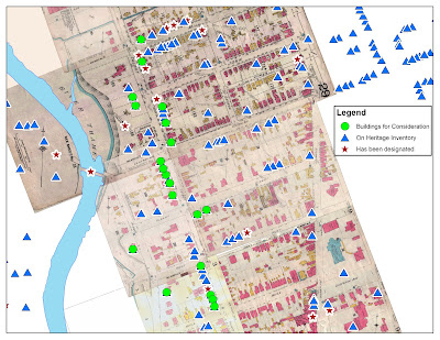
I recently received an introduction to GIS from Don Lafreniere, a graduate student in the Geography Department of UWO. Don showed some of my fellow students and me the things they were doing with GIS as historical geographers, much of which related directly to public history. For example, my classmates and I are currently researching homes in London neighbourhood to determine whether they qualify as historic resources. One criteria of significance in Ontario is contextual value, where the property is important in defining, maintaining or supporting the character of an area, or is physically, functionally, visually, or historically linked to its surroundings. (Designating Heritage Properties, Ontario Heritage Toolkit). We asked Don to create a map including all of our buildings, all the buildings in the area that are already designated, and all the buildings in the area that were included on the most recent heritage inventory (meaning they have been identified as significant but not yet designated). The resulting map took him only a few minutes to make, but should prove very useful when we argue for the contextual worth of our buildings to the local heritage review board.
GIS is certainly not new technology to heritage planners, but volunteer heritage boards have likely not had as much experience with the possibilities presented by GIS. Having someone at the meetings manipulating maps in real-time would make their decisions of what to designate, particularly when it comes to heritage areas, much easier. Saving the sequence of maps they created and viewed would also help them explain their reasoning latter, and would help establish more concrete precedents for them to look back on in the future.
One project the UWO geographers are working on is using GIS to map historic photographs, which would be an amazing resource for archives and those researching in them. The basic idea is to scan historic photos, tag them using Picasa(free software from Google) and then plot them with GIS so they will appear as points on a map. This project employs two of the most commonly used archival resources, maps and photos, and will help archives make these materials more accessible both physically and intellectually.
Because many of the users of an online geographically referenced historic photo collection would be non-academic, it is worth discussing how we can get the public to engage in the project. One way in which this could be done is through folksonomies (see The Hive Mind: Folksonomies and User-Based Tagging). Many archival collections have hundreds of thousands, if not millions of photographs, and the volume is far too large for archives, which struggle for funding as it is, to do it themselves. Having denizens of the internet tag the photos with geographic locators and keywords is a reasonable solution. One of the major criticisms of such an approach is that there is no unified language used in the description. For this reason, I would advocate creating an extensive list of keywords from which the user would have to choose, based on a codified list of terminology commonly accepted by archives, such as the UNESCO Thesaurus. An “other” category could exist which would allow the user to create their own tag, but it could not be the only identifier used. The “other” field would allow users to create their own meaning out of photos while giving project administrators an idea as to any popular tags they may have missed. Controlling the tags would also eliminate spelling errors, and allow for both keyword searches and Faceted Navigation.
Unfortunately, GIS is proprietary software and is currently too expensive for many non-profit institutions. However, the potential is there for an extremely useful, interactive tool that would help promote and engage the public with their past.
Subscribe to:
Posts (Atom)
